Arctic air to sweep UK bringing midweek cold snap
Samael.lol – This week, a surge of Arctic air is expected to cross the UK, heralding a midweek cold snap that will disrupt the spring warmth many have experienced in recent days. As colder conditions take hold, temperatures across much of the country will dip significantly below the typical mid-May averages. The shift in weather is set to bring a range of effects, from icy conditions in elevated regions to fluctuating temperatures that could see both chill and mild spells. While the overall trend is toward cooler temperatures, there are still pockets of the UK where spring-like conditions may persist, particularly as the week progresses.
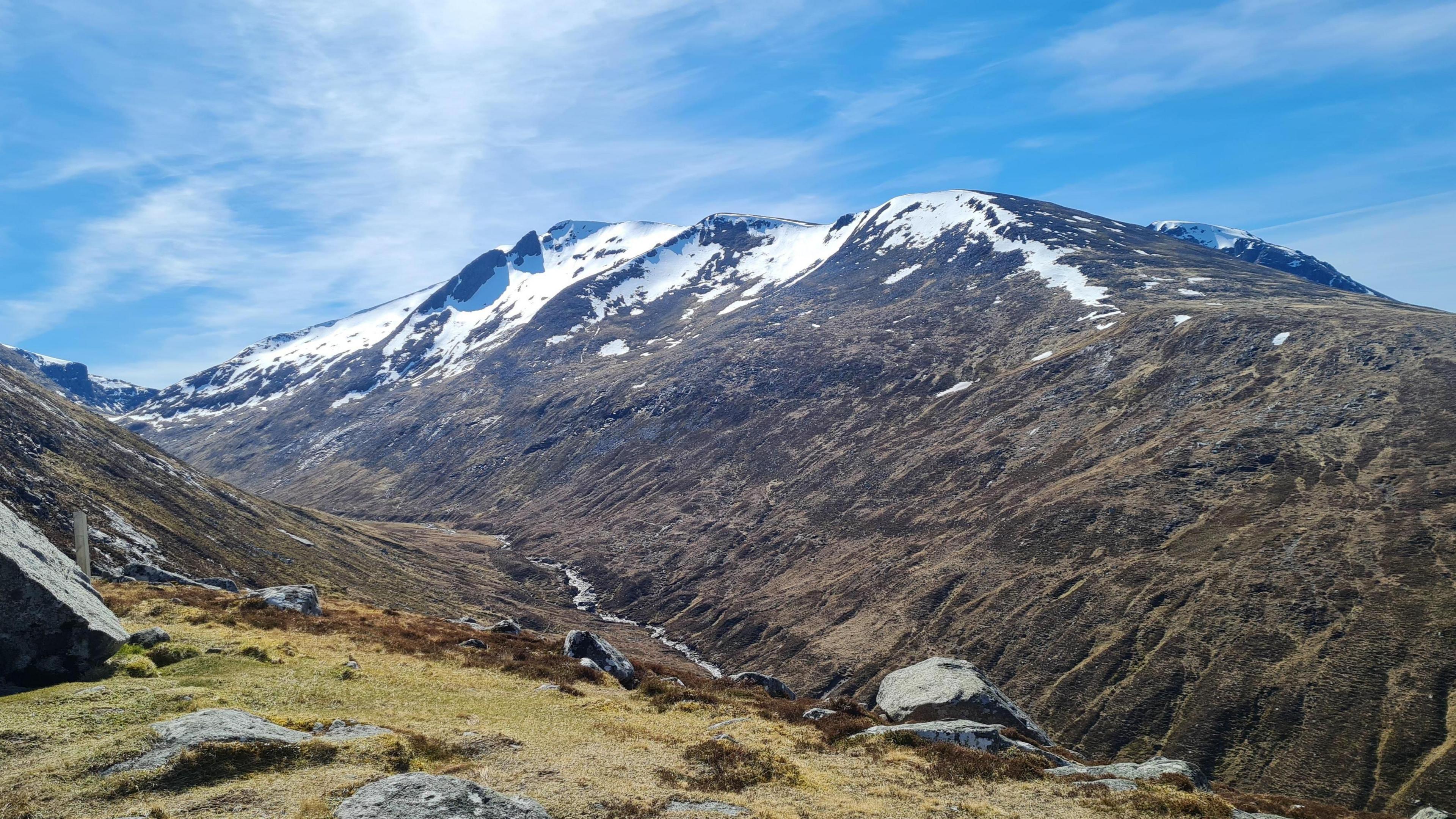
The arrival of this Arctic influence is likely to result in a mix of weather patterns, with periods of rain and showers interspersed between calmer days. In higher areas, such as the Scottish Highlands and parts of northern England, snow could be possible, especially during the latter part of the week. These wintry conditions may linger in mountainous regions, creating a stark contrast to the milder temperatures expected in lowland areas. However, the transition from cold to warm will not be straightforward, as the weather system continues to evolve throughout the week.
Forecasters have noted that the cold air will initially arrive on Monday, accompanied by a northerly wind that will keep temperatures subdued. For most of the UK, daytime highs are projected to hover around 9 to 14 degrees Celsius, while nighttime lows could drop to 3 to 6 degrees, with some rural areas experiencing even colder conditions. The first few days of the week will see a dominance of low-pressure systems, which will contribute to the chill and bring additional precipitation. This could lead to a mix of drizzle and heavier downpours, particularly in western regions, while eastern areas might see drier spells.
Despite the colder air, there are signs of a temporary reprieve. By the later part of the week, stronger spring sunshine is anticipated, combined with lighter winds, which could provide a brief period of pleasant warmth. This fluctuation in weather highlights the unpredictable nature of spring, where temperatures can swing dramatically depending on wind direction. For instance, a southerly breeze could usher in warmer air from the Mediterranean, potentially pushing temperatures into the high twenties. Conversely, northerly winds will continue to draw in the frigid Arctic air, keeping the UK cooler than usual.
“We recorded the highest temperature of the year so far with 26.6C in Kew Gardens, London, during early April.”
The dramatic temperature shifts seen in early April serve as a reminder of the UK’s seasonal volatility. As the Arctic air moves in, it will not only lower temperatures but also alter the usual weather patterns. This is particularly evident in areas like Tomintoul, Moray, where overnight temperatures fell to -6.8C last week—marking the lowest May temperature since 1997. Such extremes underscore the potential for significant weather variation as the country transitions from winter to summer.
While the cold snap will dominate the early part of the week, temperatures are expected to gradually return to normal by the end of the week. This warming trend could be accompanied by rain, which might ease the chill but also bring a risk of wet conditions. The combination of cold air and moisture may lead to a mix of light rain and drizzle, with some regions experiencing heavier showers. This is a critical time for gardeners, as the lingering frost and cold conditions could impact plant growth. However, the resumption of average temperatures later in the week may offer a more favorable outlook for outdoor activities.
The cold air’s journey from northern Scandinavia and the Arctic Circle is a key factor in this weather shift. As these winds strengthen, they will carry a noticeable chill across the UK, particularly in the early part of the week. This will create a challenging environment for those accustomed to the milder spring conditions, with the potential for icy patches on roads and sidewalks. The contrast between the cold air and the residual warmth from earlier in the season will be most pronounced in the central and southern regions, where temperatures may rise slightly on Tuesday before dropping again from Wednesday onward.
Spring is inherently a transitional period, marked by the interplay of opposing weather systems. The UK’s location makes it particularly susceptible to these shifts, as wind direction can dramatically influence the climate. During the week, the dominance of northerly winds will keep the temperature range tight, with highs struggling to exceed the mid-teens. Meanwhile, the potential for southerly breezes adds an element of unpredictability, as they could temporarily raise temperatures and create a more summery feel. This dynamic interplay between cold and warm air will shape the week’s weather, offering a mix of challenges and surprises.
The cold snap is expected to persist into the weekend, with the possibility of light rain and snow in elevated areas continuing to the following week. This could result in a prolonged period of cooler than average conditions, raising questions about whether the UK is on track for another drought this summer. While the immediate focus is on the midweek cold, the broader implications of this weather pattern will need to be monitored closely. If the Arctic influence remains strong, it could lead to a scenario where the UK experiences a delayed summer, with temperatures fluctuating between cool and warm spells.
As the Arctic air sweeps through the UK, it’s clear that the country will be experiencing a significant contrast in weather. The colder temperatures will not only affect the day-to-day lives of residents but also have an impact on the environment, including the natural habitats of wildlife and the condition of the soil for planting. This week’s weather serves as a reminder of the UK’s sensitivity to global atmospheric changes, as the cold air from the north is a stark contrast to the warmer air that has been influencing the region recently. The transition from one weather regime to another will continue to be a defining feature of the spring season.
For those in Scotland, the cold air may bring more pronounced effects, with the potential for wintry showers and frosty mornings. The Scottish Highlands, in particular, could see a mix of light snow and rain, creating a challenging landscape for travelers and outdoor enthusiasts. In contrast, southern England might experience a more moderate chill, with the coldest air being less severe. However, even in these regions, the temperature drops will be noticeable, particularly when compared to the earlier warmth of the season.
As the cold air moves in, it’s also worth noting the role of the UK’s geography in shaping these weather patterns. The country’s position between the Atlantic and continental Europe means that it is constantly influenced by different air masses. This week’s weather will be no exception, with the Arctic air providing a temporary setback to the warming trend. While the cold snap may not last for the entire week, its presence is a key factor in the UK’s seasonal weather variability. The combination of colder temperatures and precipitation will create a unique set of conditions that residents will need to adapt to.
Overall, the arrival of Arctic air is set to bring a noticeable change in the UK’s weather, with a midweek cold snap that could last for several days. While the cold conditions may be challenging for some, they also offer a chance to experience the more traditional spring weather patterns. As the week progresses, the interplay between the cold air and the residual warmth will continue, ensuring that the UK remains a place of weather extremes. This week’s forecast is a testament to the unpredictable nature of spring, where one day’s warmth can give way to the next day’s chill.